Learn about Global atmospheric circulation
Part of:
Climate and Energy HIWAVESWhat is it?
The global atmospheric circulation model is a simplified version of how air currents in the atmosphere move. It is used to help explain weather patterns and climatic regions.
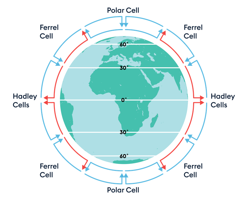
The global atmospheric circulation model is based around cells. These cells are regions where the air moves from low pressure to high pressure. There are three cells in each hemisphere.
Either side of the equator is the Hadley cell, with the Ferrell cell next and then the Polar cell at the top and bottom of the planet.
How does air circulate?
 Encounter Edu
Within each cell, the air moves in a circular fashion. Taking the Hadley cell, warm air at the equator (0° of latitude) rises and then cools in the upper atmosphere, then circles back down towards the tropics (i.e. 30° of latitude).
The air in the Ferrell cell moves in the opposite direction to the air in the Hadley cell with warm air moving toward the polar regions. The warm air that has travelled up from the equator converges with the cold air at 60° of latitude that has travelled down from the polar regions. As the air converges the warm air is forced to rise and move back towards the equator.
The overall effect of the Polar cell is to move cold air towards the equator. At the poles (i.e. 90° of latitude) the cold air sinks. It then moves towards the equator. At 60° the combination of warm and cold air causes the warm air to rise, resulting in low air pressure at 60°. At 60° latitude the polar front is found. This is the result of the warm air that has travelled up from the equator and cold air from the poles being unable to mix well.
The Hadley and Polar cell are controlled by the suns heat (thermally direct) whereas the is Ferrell cell is controlled by the other two cells and how the air is moving in them causing it to be thermally indirect.
What is the global atmospheric system?
The global atmospheric system is a natural system that acts to reduce the extreme heat difference between the equator and the poles. As the air is moved around, it prevents the equator becoming increasingly hotter and the poles becoming increasingly colder.
How does the global atmospheric circulation model affect weather patterns?
Due to the Coriolis affect (the Earth’s spin), when the air is moving in the different cells, it is forced to move in different directions, and this has an impact on the prevailing wind direction.
The global atmospheric system impacts jet streams. Due to differences in air temperature and pressure at 30° and 60° latitude a jet stream is formed, the greater the difference between the air temperatures, the stronger the jet stream. The Polar jet stream can have an impact on the weather of mid latitude countries such as the UK. When the jet stream is further north, it allows the more settled warmer conditions found to the south of the jet stream to occur in the UK. Consequently, when the Polar jet stream moves further south the unsettled colder weather located north of the jet stream will occur in the UK.
How does the global atmospheric circulation system affect climate zones?
There are many conditions that can affect the climate of a location including distance from the sea, ocean currents, relief of the land, distance from the equator and the prevailing wind direction.
There is clearly some correlation between climate and the global atmospheric circulation model and consequently the location of major physical landscapes and ecosystems.
At the equator (i.e. 0° of latitude) there is low air pressure and the air is very warm, this results in tumultuous weather with regular storms. The hot temperatures and high rainfall are the perfect conditions for tropical rainforests.
At 30° of latitude there is high air pressure caused by the air from the Hadley and Ferrell cells converging. This results in very settled weather, with a distinct lack of precipitation. At 30° latitude the temperature is hot. These conditions have resulted in the formation of deserts.
At 60° of latitude the temperature is much cooler, but with low air pressure it is unsettled. This results in the weather we experience in the UK, with distinctive wet and cold winters and warm summers.
At the poles (i.e. 90° of latitude) there is high pressure. This results in settled weather, although it is extremely cold in the polar regions the lack of cloud and subsequent rain means there are deserts in the Polar Regions as well.

Geography | Ages 14-16
Climate and Energy
Climate and Energy is an exciting unit which invites students to explore the connection between the global climate and energy use both locally and internationally, with a focus on renewable energy.